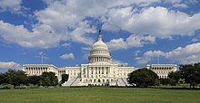
Pennsylvania Avenue is a diagonal street in Washington, D.C., and Prince George's County, Maryland, that connects the White House and the United States Capitol and then crosses Washington, D.C. before entering Maryland. In Maryland, it becomes MD Route 4 (MD 4) and then MD Route 717 in Upper Marlboro, and finally Stephanie Roper Highway. The section between the White House and Congress is sometimes referred to as "America's Main Street";[1] it is the location of official parades and processions, and periodic protest marches. Pennsylvania Avenue is an important commuter road and is part of the National Highway System.[2][3]
Route[edit]
The avenue runs for 5.8 miles (9.3 km) inside Washington, D.C., but the 1.2 miles (1.9 km) of Pennsylvania Avenue from the White House to the United States Capitol building is far and away the most famed section of the avenue. It continues within the city for 3.5 miles (5.6 km), from the southeast corner of the Capitol grounds through the Capitol Hill neighborhood, and over the Anacostia River on the John Philip Sousa Bridge. Crossing most of Prince George's County, Maryland, it ends 9.5 miles (15.3 km) from the Washington, D.C. border in Maryland at the junction with MD 717 in Upper Marlboro, where the name changes to Stephanie Roper Highway, for a total length of 15.3 miles (24.6 km). Stephanie Roper Highway used to be Pennsylvania Avenue, but was renamed in 2012. In addition to its street names, in Maryland it is designated as Maryland Route 4.
Northwest of the White House, Pennsylvania Avenue runs for 1.4 miles (2.3 km) to its end at M Street N.W. in Georgetown, just beyond the Pennsylvania Avenue Bridge over Rock Creek. From 1862 to 1962, streetcars ran the length of the avenue from Georgetown to the Anacostia River.
https://en.wikipedia.org/wiki/Pennsylvania_Avenue
*****
National Mall
The National Mall is a landscaped park near the downtown area of Washington, D.C., the capital city of the United States. It contains and borders a number of museums of the Smithsonian Institution, art galleries, cultural institutions, and various memorials, sculptures, and statues. It is administered by the National Park Service (NPS) of the United States Department of the Interior as part of the National Mall and Memorial Parks unit of the National Park System.[4] The park receives approximately 24 million visitors each year.[5]
The core area of the National Mall extends between the United States Capitol grounds to the east and the Washington Monument to the west and is lined to the north and south by several museums and a federal office building.[6] The term National Mall may also include areas that are also officially part of neighboring West Potomac Park to the south and west and Constitution Gardens to the north, extending to the Lincoln Memorial on the west and Jefferson Memorial to the south.[7]
Landmarks, museums, and other features[edit]
Within the National Mall proper[edit]
The National Mall proper contains the following landmarks, museums and other features (including opening year):[7][6]
- 2. National Museum of American History (1964)[8]
- 3. National Museum of Natural History (1910)
- 4. National Gallery of Art Sculpture Garden (1999)
- 5. West Building of the National Gallery of Art (1941)
- 6. East Building of the National Gallery of Art (1978)
- 10. National Museum of the American Indian (2004) (shown under construction)
- 11. National Air and Space Museum (1976)
- 12. Hirshhorn Museum and Sculpture Garden (1974)
- 13. Arts and Industries Building (1881)
- 14. Smithsonian Institution Building ("The Castle") (1849)
- 15. Freer Gallery of Art (1923)
- 16. Arthur M. Sackler Gallery (1987)
- 17. National Museum of African Art (1987)
Not marked on the above image:
- Above the Smithsonian Institution Building
- Joseph Henry statue (1883)[9]
- Below the Smithsonian Institution Building
- Above the Arts and Industries Building
- Smithsonian Carousel (1967)[11]
- To the left of the National Museum of American History
- Site of the present National Museum of African American History and Culture (2016)[12]
- To the left of the Freer Gallery of Art
With the exception of the National Gallery of Art, all of the museums on the National Mall proper are part of the Smithsonian Institution. The Smithsonian Gardens maintains a number of gardens and landscapes near its museums.[14] These include:
- Common Ground: Our American Garden (2017)[15]
- Enid A. Haupt Garden (1987)[16]
- Freer Gallery of Art Courtyard Garden (1923)[17]
- Hirshhorn Museum and Sculpture Garden (1974)[18]
- Kathrine Dulin Folger Rose Garden (1998)[19]
- Mary Livingston Ripley Garden (1978)[20]
- National Air and Space Museum landscape (1976)[21]
- Native landscape at the National Museum of the American Indian (2004)[22]
- Pollinator Garden (1995)[23]
- Urban Bird Habitat[24]
- Victory Garden[25]
East of the National Mall proper[edit]
Features east of the National Mall proper include:
- United States Capitol and its grounds (no. 7 on image)
- Union Square, containing:
- Capitol Reflecting Pool (1971) (no. 8 on image)
- Ulysses S. Grant Memorial (1922) (east of no. 8 on image)
- Peace Monument (1878) (in traffic circle northeast of no. 8 in image)
- United States Botanic Garden (1933) (no. 9 on image)
- James A. Garfield Monument (1887) (in traffic circle northeast of no. 9 in image)


沒有留言:
張貼留言